HART MINE 1 MINE
The Hart Mine 1 mining claim consists of one (1) unpatented lode claim covering 20.66 acres on federal land managed by the U.S. Bureau of Land Management. The claims cover a former producing gold-silver mine, the Hart Mine, about 4 miles south of the town of Gold Point.
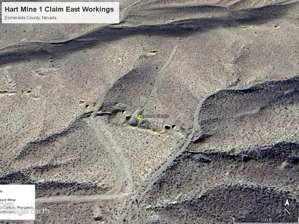
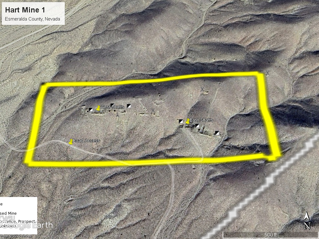
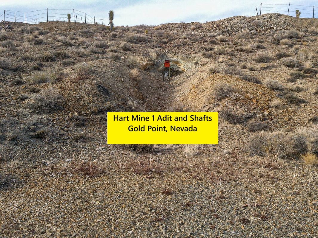
The claim has six (6) mapped mining shafts, one (1) adit (horizontal opening), and multiple small open pits, and large tailings piles (see pictures).
The Gold Point District was originally known as Hornsilver due to the extremely high silver grades of the surface ores (up to 500 ounces per ton). At about 100-200 feet depth the veins turned to gold and average 1 ounce per ton.
Location and Access: From Las Vegas drive 2.5 hours north on Highway 95 to NV-266. Turn left on NV-774 and drive 15 miles to Gold Point, Nevada (partial ghost town). Continue straight as NV-774 turns into Gold St. and head south out of town along dirt roads for 4.2 miles. There is a road that goes directly to the claim. I will provide a directions map and GPS coordinates with turnoffs.
GPS Coordinates: Lat: 37.293573° Long: -117.389524° (Hart Mine 1 Eastern Shafts).
Mining and Exploration Potential: The Gold Point District has a high density of old mine workings and numerous high-grade silver-gold veins. There is favorable geology over a wide area due to a large intrusive formation (Sylvania Pluton) that has mineralized older limestones and slates (excellent host rocks).
The Hart Mine 1 has a 1,000+ foot vein system that has been explored with shafts and adits. The veins could go quite deep and potentially have a larger feeder structure.
The tailings and dumps could hold economic values and some of the vein could be amenable to surface mining methods.
There is some alluvial (soil, gravel) cover over some of the property and the old-timers did not have good techniques for exploring these areas.
Modern exploration such as geophysics and soil geochemistry could make additional discoveries here.
The district has lots of outcrop and the host rocks are very distinctive and easy for even amateur prospectors to locate.
Some of the high-grade veins which were originally mined with underground methods have been open-pitted by small miners.
Silver and gold have given equal values. Grades of up to 100 ounce per ton silver and 1 ounce per ton gold have been recorded throughout the Gold Point area.
Recently, Teck Resources Ltd., a large publicly traded mining company with an $18B market capitalization, has optioned mining claims to the north around the town of Gold Point. This has generated interest from other mining companies in this area interested in the potential for undiscovered deposits.
There is the opportunity both for a small hardrock mine and a larger exploration play. Most of the surrounding land is BLM and there is plenty of available land to stake if you wanted to expand the property.
The Hornsilver / Gold Point District is located in southern Esmeralda County, Nevada. The Hornsilver / Gold Point District includes the townsite which has a few hardy residents. There are two large mines just south of the town on patented ground. The Tokop District is 9 miles by road SE of Gold Point. To the west of Tokop are the Oriental Wash (placer mining) and Gold Mountain, both with lots of historical mining activity. Nearby world class mining districts include Goldfield (5 mill ounces of gold), Tonopah (180 mill ounces of silver, 2 mill ounces of gold), and the Bullfrog district near Beatty, NV (2 mill. ounces of gold and growing).
District History: Prospectors started exploring the area in the mid-1860’s. Gold Mountain was one of the first mining camps in this area. Lida and Lime Point were each established in 1872. Rich pockets of silver ore were found near the surface (hornsilver) but had to be shipped great distances to Candelaria or Austin for processing which limited the growth of the district. However, the nearby State Line mine was profitable through the 1880’s.
Interest in the district renewed after the discoveries at Tonopah and Goldfield around 1900. The Great Western Mine, just south of Gold Point, started operating in 1905 and discovered rich veins of hornsilver some of which was nearly pure native silver. Production records indicate that early shipping grades of about 300-500 ounces of silver per ton.
A mining rush in the district ensued and many mines were established. Most found rich silver ore, but at some depth the veins turned into gold. When this happened the district changed its name to Gold Point. A book was written on the Hornsilver / Gold Point district by Alan Patera with the subtitle: “silver turns into gold”.
Some of the veins were fissure veins and some were contact veins, both extending to depth. Published reports from the Ohio Mine indicated grades from veins around the district averaging over 2 oz/ton gold equivalent. The Ohio Mine vein extended down to the 900 foot level. Silver prices declined through the 1920’s and some of the mines closed down.
The mines were reopened and the district experienced a revival during Depression until 1942 when the mines were closed down for WWII. Like many small mining districts in the US, Gold Point and Tokop never restarted after WWII. There has been limited modern exploration in this district.
Regional Geology: The Hart Mine 1 claim is located in the Walker Lane mineral belt which is part of the Basin and Range physiographic province. The Basin and Range province covers most of Nevada and consists of narrow NE trending mountain ranges between flat, arid valleys and basins.
The Walker Lane mineral belt is an area with a high density of parallel strike-slip faults extending from Reno to Las Vegas roughly along the California- Nevada border. Faulting and volcanic activity make the Walker Lane favorable for hosting gold and silver deposits including some of the most famous precious metal mining districts in the US including the Comstock, Goldfield, Tonopah, Bullfrog, Mineral Ridge, and Round Mountain.
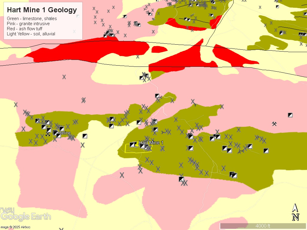
Local Geology: The Hart Mine 1 Claim is in a east-west trending exposure of Wyman Formation sedimentary rocks to the north of Oriental Wash.
The Wyman Formation exposure is 7 miles long by about .25 miles wide. It covers the entire Hart Mine 1 claim. The norther Wyman Formation outcrop is part of the Teck / GRG Joint Venture. The southern exposure is part of our claims and could form the basis of a professional portfolio.
The veins are found in fissures and along the bedding planes of the shales.
From the Baker Report on the Hart Mine: “Diggings are on zones of alteration – Fe stained, softened, yellow-green alteration, some bleaching, and usually accompanied by shearing and indistinct quartz veins, vuggy, iron-stained. Mostly trend west-northwest.”
The workings on the Hart Vein are 1,000 feet long. The vein may extend beyond these limits and just have been covered in soil and gravel.
There is faulting and fissure in west-northwest trend parallel to the trend of the Wyman Formation and intrusive contact. There is an intrusive contact both north and south of the Hart Mine 1 claim
The combination of extensive faulting, reactive host rocks and a volcanic source has created some large and high-grade deposits.
Available Reports:
Albers, J.P. and Stewart, J.H., Geology and Mineral Deposits of Esmeralda County, Nevada, Nevada Bureau of Mines and Geology, 1972.
Baker, Arthur, III, ‘Scouting Report on Stateline Mill and Hart Silver Mine Areas’, Private Report. 1966.
Patera, A., ‘Hornsilver / Gold Point Nevada’, Western Places No. 26, Western Places, 2003.
Patera, A., ‘Gold Mountain Nevada’, Western Places No. 27, Western Places, 2004.
Tingley, J.V., Tokop District Summary Report, Nevada Bureau of Mines and Geology, 1983.
FAQ
Why Nevada?
Nevada is consistently ranked as one of the top mining jurisdictions in the world for being mining-friendly and continuing to produce major discoveries. If Nevada was a country it would be the 5th largest gold producer in the world (after Australia, Canada, China, and Russia). Nevada is home to the Carlin Trend, the Cortez Trend, the Walker Lane Trend, the Getchell Trend and many other prolific gold producing regions. In addition to gold Nevada also has major mines producing silver, copper, lithium, iron ore, magnesium, gems and many other minerals. Nevada is 85% owned by the federal government and most of this land is available for claim staking. This means some of the best mining ground in the world is open to small prospectors – a very unique situation. There are many mining companies active in Nevada and therefore, multiple potential buyers for any discovery you make. Canadian based junior exploration companies are particularly active in Nevada.
Why Buy a Claim?
Buying a claim is a great way to get started in mining and prospecting. Buying a claim that is professionally staked reduces your upfront work and the risk of making a mistake on your paperwork or in the field. Our claims are in areas with historical mining activity and most have numerous pits, shafts, and adits to explore. Finding these claims takes lots of research that is already done for you. The best place to find gold is where people have already found it!
Why Us?
I have been working in mineral exploration in the southwestern United States and Alaska for 17 years. I have co-founded four junior mining companies and managed numerous drilling and exploration projects. I have worked with large and small mining companies and know what types of projects they are looking for that can be advanced by small prospectors. I have also worked on small hardrock production projects. I usually try to find claims that have known high grade veins that can be produced and that also have some exploration upside. We stand by our claims and fix any problems that come up. We can also help you with your annual filings. All our claims have a BLM serial number and can be found on the U.S. BLM MLRS website database. We hire the same professional claim staking companies that the large mining companies hire and all the claims have professionally drafted and accurate maps.
How is ownership of the claim transferred?
Ownership of mining claims is transferred with a Quitclaim Deed which we prepare. We pay all claim transfer fees and file the claim transfer paperwork with the BLM and Esmeralda County. The BLM takes about 2-3 weeks to process the claim transfer (Quitclaim Deed) and register the claim in your name. We file with the Esmeralda County Recorder electronically and they usually return the recorded Quitclaim Deed same day. Once the transfer is complete we will send you all the original documents including the file stamped Quitclaim Deed, the original location notices and claim maps.
How Much are the Annual Claim Fees?
The BLM charges a $200 per claim annual maintenance fee which is due on September 1st each year. The BLM fees can be paid online through their claim management portal. Esmeralda County requires that a Notice of Intent to Hold form is filed the first year by Nov 1st along with payment of the recording fee of $12 plus $12 per claim.
If you own less than 10 mining claims you can qualify for a waiver of the annual maintenance fee by filing a Small Miner’s Waiver. However, the Small Miner’s Waiver requires that you perform $100 in labor or improvements on the claim each year.
International Buyers
International buyers must either have dual US citizenship and US address or have a US entity or company to own the claim.