
Mastering a few tricks on Google Earth and finding the right data can make finding old mines super-easy.
Learning a mapping program is essential to success as a prospector or miner. About 10 years ago I took a GIS (Geographical Information Systems) class at the San Diego Community College. They taught me how to use ArcGIS, one of the best known mapping software tools used by big companies and government.
ArcGIS is published by ESRI and is an amazing tool. Any kind of map you can conceive of can be produced by ArcGIS. I use it for claim maps, geological maps, drilling maps, soil maps, and anything that is They sell an annual license for personal use for $100. Here is the link: https://www.esri.com/en-us/arcgis/products/arcgis-for-personal-use/buy
ArcGIS is a very powerful, but can also be complicated and the learning curve is a little steep. ESRI has tons of free online tutorials, but these can soak up lots of hours.
If you want something simple – nothing beats Google Earth. You can download Google Earth Pro for your PC here: https://www.google.com/earth/download/gep/agree.html?hl=en-GB
Google does software almost better than anyone else. They love simple and intuitive and Google Earth can be learned almost with no instruction. However, there are tons of free videos on how to use it.
The great thing about Google Earth is that you can add overlays to the basic satellite map. You can add topo maps, soil maps, magnetic maps, etc. These overlays are Google Earth files which have a .kmz or .kml file extension. KML stands for Keyhole Markup Language and is the basic file type that Google Earth handles.
For prospectors, we can find .kmz files which help us find and research old mines.
The two most important databases for mining are the USMIN database and the MRDS database.
USMIN is the set of mine related features that go on topographic maps. You may have seen some of these symbols on your topo maps:
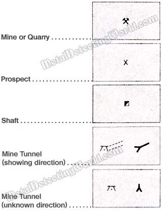
Almost all the shafts, adits, and other mine features have been mapped. The USMIN database is organized by state and you can download the complete set of mine features for every state.
The USGS has a download site for the Google Earth (.kmz) files for the USMIN database here: https://mrdata.usgs.gov/usmin/