GCE 24 MINING CLAIM
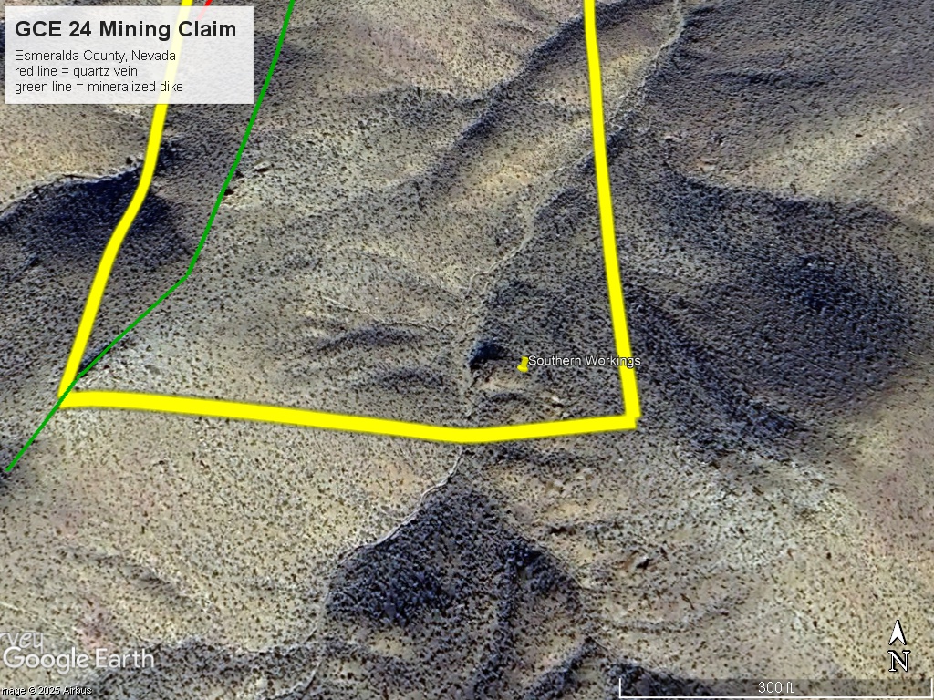
The GCE 24 mining claim consists of one (1) unpatented lode claim covering 20.66 acres on federal land managed by the U.S. Bureau of Land Management. The claim is located in the Gold Point District in Esmeralda County, Nevada (also known as the Hornsilver District).
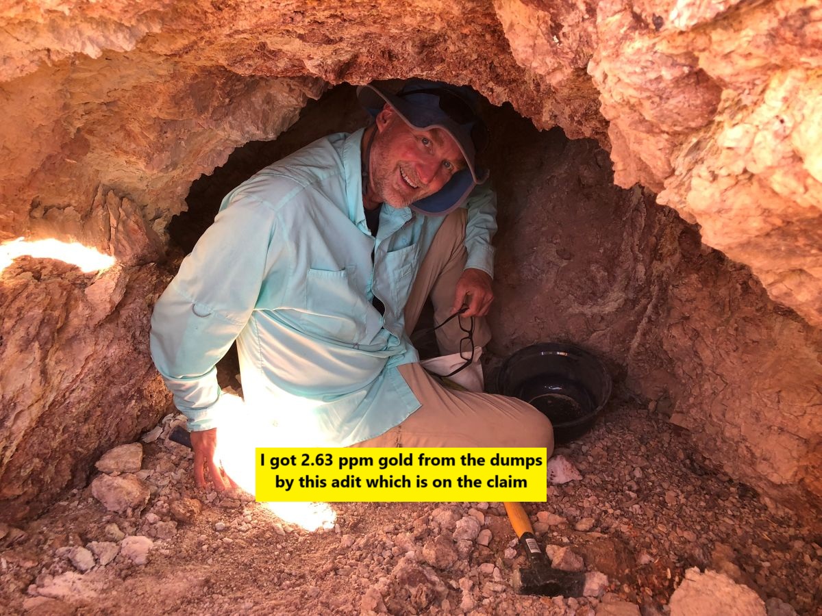
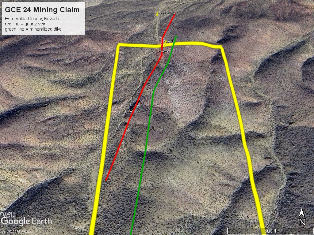
The claim has a quartz vein that runs 700 feet across the claim and a mineralized dike that runs the entire length of the claim. I sampled some of the quartz veins and it assayed 2.63 ppm (.077 ounces per ton). To the north about 1000 feet I took another sample which ran 9.76 ppm gold (.28 ounces per ton).
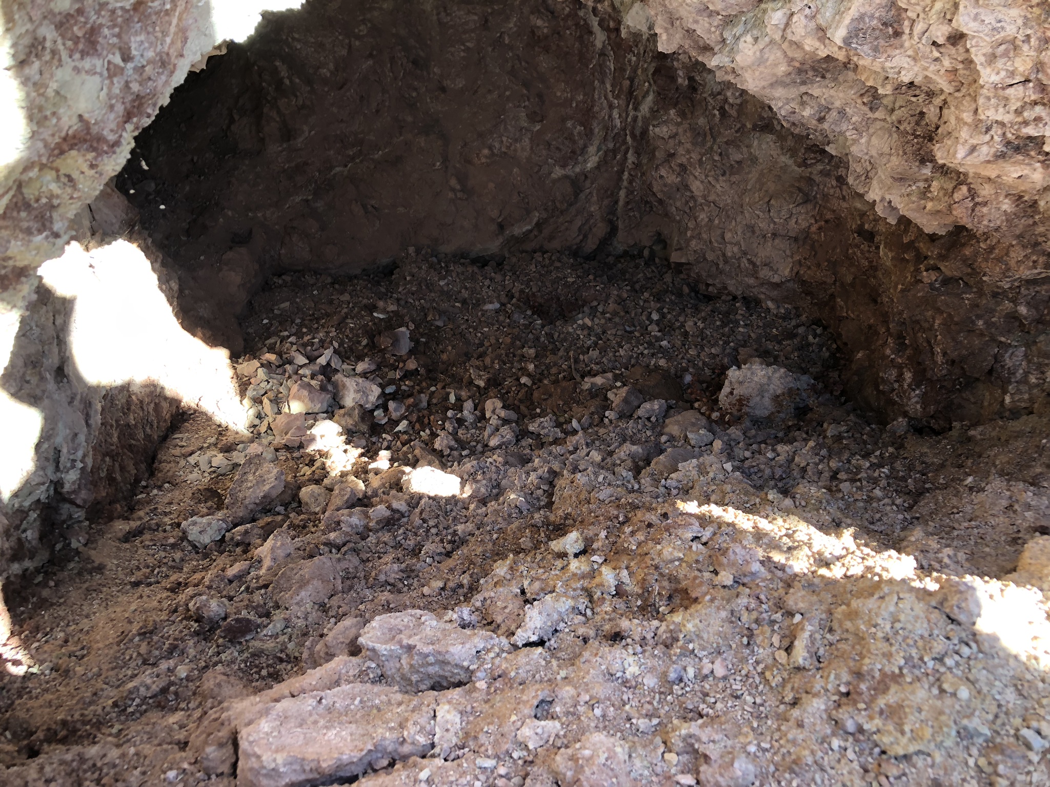
There is an adit at the north end of the claim with some tailings and ore piles.
In the washes there are azurite and malachite (copper minerals) in float.
The Tokop / Gold Mountain area is well known for high grade silver and gold veins. Grades as high as 5 ounces per ton gold were shipped during the early years of the production.
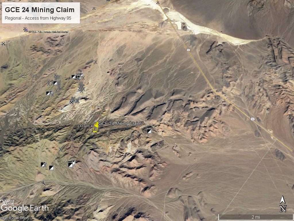
Location and Access: From Beatty, Nevada drive north on US Highway 95 for 42.4 miles. Take a left at a dirt road turnoff and drive west for 5 miles on dirt roads. The roads are graded and generally in good condition. The claim can be reached by a ATV and Jeep trail from the graded road. Beatty, Nevada is a 1 hour 45 minutes drive north on US Highway 95.
GPS Coordinates: Lat: 37.361849° Long: -117.216844° (Adit where I got the 2.63 g/t sample).
Mining and Exploration Potential: The Gold Point / Tokop districts have a high density of old mine workings and numerous high-grade silver-gold veins. There is favorable geology over a wide area due to a large intrusive formation (Sylvania Pluton) that has mineralized older metasediments.
There is a long mineralized dike system running north-south on the claim. These carry good gold values and could be further defined with geophysics or field mapping. There is also a semi-parallel system of quartz veins that is offset 50-100 feet to the west from the dike.
The quartz veins could carry about .25 to .50 ounces per ton gold over a strike length of 750 feet. Assuming a two foot vein width and depth to 30 feet this would give an approximate potential of 2500 ounces that could be mined with surface methods. (this is just a guesstimate)
The district has lots of outcrop and the host rocks are very distinctive and easy for even amateur prospectors to locate.
Some of the high-grade veins which were originally mined with underground methods have been open-pitted.
Silver and gold have given equal values. Grades of up to 100 ounce per ton silver and 1 ounce per ton gold have been recorded throughout the Tokop / Gold Mountain area. A memo from the Hughes Tool Company (Howard Hughes was active in this area) mentions grades of 1 opt gold and 50-100 opt silver in a nearby mine.
Due to recent discoveries in the nearby Bullfrog district there is renewed interest in Walker Lane properties such as the Gold Coin.
There is the opportunity both for a small hardrock mine and a larger exploration play. Most of the surrounding land is BLM and there is plenty of available land to stake if you wanted to expand the property.
In addition to the gold potential there is potential for gem-grade and collector grade copper minerals. There is a unique super-saturated basalt foam with copper oxide crystals. This is a very interesting material that might generate some collector interest.
Copper oxide minerals of this quality sell for about $20-40 per pound on online markets and there could be 10 tons or more of this material that could be collected from in-place veins and float.
The Tokop and Hornsilver / Gold Point Districts lie in southern Esmeralda County, Nevada. The Hornsilver / Gold Point District includes the townsite which has a few hardy residents. There are two large mines just south of the town on patented ground. The Tokop District is 9 miles by road SE of Gold Point. To the west of Tokop are the Oriental Wash (placer mining) and Gold Mountain, both with lots of historical mining activity. Nearby world class mining districts include Goldfield (5 mill ounces of gold), Tonopah (180 mill ounces of silver, 2 mill ounces of gold), and the Bullfrog district near Beatty, NV (2 mill. ounces of gold and growing).
District History: Prospectors started exploring the area in the mid-1860’s. Gold Mountain was one of the first mining camps in this area. Lida and Lime Point were each established in 1872. Rich pockets of silver ore were found near the surface (hornsilver) but had to be shipped great distances to Candelaria or Austin for processing which limited the growth of the district. However, the nearby State Line mine was profitable through the 1880’s.
Interest in the district renewed after the discoveries at Tonopah and Goldfield around 1900. The Great Western Mine, just south of Gold Point, started operating in 1905 and discovered rich veins of hornsilver some of which was nearly pure native silver. Production records indicate that early shipping grades of about 300-500 ounces of silver per ton.
A mining rush in the district ensued and many mines were established. Most found rich silver ore, but at some depth the veins turned into gold. When this happened the district changed its name to Gold Point. A book was written on the Hornsilver / Gold Point district by Alan Patera with the subtitle: “silver turns into gold”.
Some of the veins were fissure veins and some were contact veins, both extending to depth. Published reports from the Ohio Mine indicated grades from veins around the district averaging over 2 oz/ton gold equivalent. The Ohio Mine vein extended down to the 900 foot level. Silver prices declined through the 1920’s and some of the mines closed down.
The mines were reopened and the district experienced a revival during Depression until 1942 when the mines were closed down for WWII. Like many small mining districts in the US, Gold Point and Tokop never restarted after WWII. There has been limited modern exploration in this district.
Regional Geology: The GCE 24 claim is located in the Walker Lane mineral belt which is part of the Basin and Range physiographic province. The Basin and Range province covers most of Nevada and consists of narrow NE trending mountain ranges between flat, arid valleys and basins.
The Walker Lane mineral belt is an area with a high density of parallel strike-slip faults extending from Reno to Las Vegas roughly along the California- Nevada border. Faulting and volcanic activity make the Walker Lane favorable for hosting gold and silver deposits including some of the most famous precious metal mining districts in the US including the Comstock, Goldfield, Tonopah, Bullfrog, Mineral Ridge, and Round Mountain.
Local Geology: The host rocks are Poleta Formation and Deepsprings Formation – Cambrian sedimentary rocks consisting of inter-layered limestone, siltsone, and quartzite.
The Cambrian sediments are intruded by Tertiary quartz porphyry dikes running north-south (see picture above).
We assayed some of the dike material at ALS Geochemistry Labs and got a value of 9.76 ppm gold. There was a 2.63 ppm gold value on the same dike south of the claim boundary. But this means that the dikes are mineralized over a long strike length.
There is soil cover that probably obscures additional dikes and vein material.
The mineralization may be related to a nearby horst-graben feature where the dikes seem to radiate from.
Available Reports:
Albers, J.P. and Stewart, J.H., Geology and Mineral Deposits of Esmeralda County, Nevada, Nevada Bureau of Mines and Geology, 1972.
Janin, C., ‘Report on the Property of the Gold Mountain Mining Company’, 1912.
Patera, A., ‘Hornsilver / Gold Point Nevada’, Western Places No. 26, Western Places, 2003.
Patera, A., ‘Gold Mountain Nevada’, Western Places No. 27, Western Places, 2004.
Tingley, J.V., Tokop District Summary Report, Nevada Bureau of Mines and Geology, 1983.
Travis, M., ‘Gold Coin Project – Technical Memo’, Private Report, 2024.
FAQ
Why Nevada?
Nevada is consistently ranked as one of the top mining jurisdictions in the world for being mining-friendly and continuing to produce major discoveries. If Nevada was a country it would be the 5th largest gold producer in the world (after Australia, Canada, China, and Russia). Nevada is home to the Carlin Trend, the Cortez Trend, the Walker Lane Trend, the Getchell Trend and many other prolific gold producing regions. In addition to gold Nevada also has major mines producing silver, copper, lithium, iron ore, magnesium, gems and many other minerals. Nevada is 85% owned by the federal government and most of this land is available for claim staking. This means some of the best mining ground in the world is open to small prospectors – a very unique situation. There are many mining companies active in Nevada and therefore, multiple potential buyers for any discovery you make. Canadian based junior exploration companies are particularly active in Nevada.
Why Buy a Claim?
Buying a claim is a great way to get started in mining and prospecting. Buying a claim that is professionally staked reduces your upfront work and the risk of making a mistake on your paperwork or in the field. Our claims are in areas with historical mining activity and most have numerous pits, shafts, and adits to explore. Finding these claims takes lots of research that is already done for you. The best place to find gold is where people have already found it!
Why Us?
I have been working in mineral exploration in the southwestern United States and Alaska for 21 years. I have co-founded four junior mining companies and managed numerous drilling and exploration projects. I have worked with large and small mining companies and know what types of projects they are looking for that can be advanced by small prospectors. I have also worked on small hardrock production projects. I usually try to find claims that have known high grade veins that can be produced and that also have some exploration upside. We stand by our claims and fix any problems that come up. We can also help you with your annual filings. All our claims have a BLM serial number and can be found on the U.S. BLM MLRS website database. We hire the same professional claim staking companies that the large mining companies hire and all the claims have professionally drafted and accurate maps.
How is ownership of the claim transferred?
Ownership of mining claims is transferred with a Quitclaim Deed which we prepare. We pay all claim transfer fees and file the claim transfer paperwork with the BLM and Esmeralda County. The BLM takes about 30 days to process the claim transfer and register the claim in your name. We file electronically with Esmeralda County and usually get the paperwork back same day. Once the transfer is complete we will send you all the original documents including the file stamped Quitclaim Deed, the original location notices and claim maps.
How Much are the Annual Claim Fees?
The BLM charges a $200 per claim annual maintenance fee which is due on September 1st each year. The BLM fees can be paid online through their claim management portal. Esmeralda County requires that a Notice of Intent to Hold form is filed the first year by Nov 1st along with payment of the recording fee of $12 plus $12 per claim.
If you own less than 10 mining claims you can qualify for a waiver of the annual maintenance fee by filing a Small Miner’s Waiver. However, the Small Miner’s Waiver requires that you perform $100 in labor or improvements on the claim each year.
International Buyers
International buyers must either have dual US citizenship and US address or have a US entity or company to own the claim.