
Hualapi Gold 6
 1 / 5
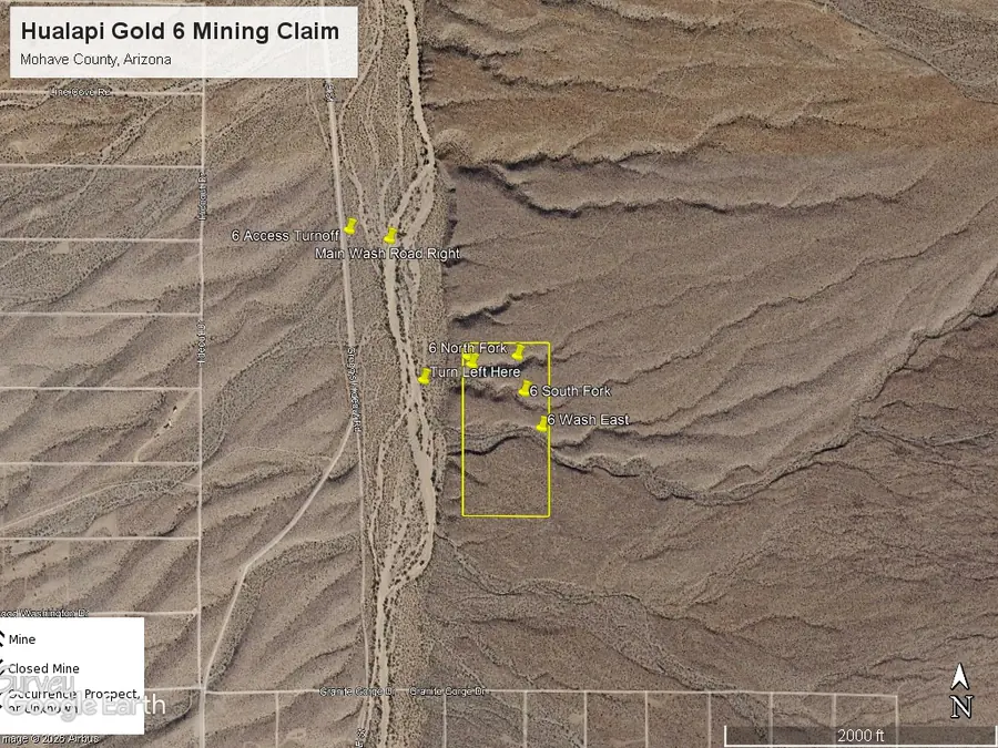
Regional aerial overview: Hualapi Gold 6 boundary outlined in yellow, Hualapai Wash and access turnoff to the west, with the claim's drainage forks identified.
Explore in 3D
Open full-screen viewRotate and zoom the terrain to explore the claim boundary, aerial imagery and mapped historical workings.
The 3D view labels Hualapai Wash west of the claim. Rotate and zoom to examine the original boundary, feeder washes and mapped historical workings. Confirm road access separately.
Property details
Hualapi Gold 6 is a 20-acre unpatented placer mining claim in the Lost Basin Mining District of Mohave County, Arizona, near Hualapai Wash and the Lost Basin Range. It occupies a narrow block of desert foothill terrain with short arroyos descending toward the main wash. The property is offered with claim boundary, aerial, topographic and directions maps available in the information package.
Claim details
- Claim: Hualapi Gold 6 (spelling as recorded)
- Claim type: Unpatented placer
- Size: 20 acres, approximately 1,320 by 660 feet
- Location: E½ NE¼ SW¼, Section 24, T29N, R18W, Gila & Salt River Meridian, Mohave County, Arizona
- Setting: Foothill drainages east of Hualapai Wash, west side of the Lost Basin Range
Mining history and production
Gold-bearing quartz veins were discovered in the neighboring Gold Basin and Lost Basin districts in the 1870s. According to the U.S. Geological Survey, 13,508 ounces of gold and 6,857 ounces of silver were recorded from the combined districts during 1901–1942. Most recorded lode production came from the Gold Basin hardrock mines to the southwest; historic placer output was not comprehensively reported. These figures describe the districts, not Hualapi Gold 6.
Placer mining in the broader Lost Basin area included the King Tut, Lone Jack and Queen Tut operations. A November 2007 historical report credits the King Tut operation with approximately 1,200 ounces of gold in its 1930s mining period. King Tut's better-known gold-bearing channels lie primarily along the eastern flank of the Lost Basin Range, whereas Hualapi Gold 6 is situated on the western side near Hualapai Wash. This distinction is important when evaluating the property's geology.
Geology and placer potential
USGS Professional Paper 1361 describes gold-bearing veins in ancient metamorphic rocks and placer gold distributed in alluvial fans, washes and reworked gravel deposits. Smaller historic placer occurrences are documented on the western flank of the Lost Basin Range. The Hualapi Gold 6 maps show several short, shallow drainages crossing the claim toward Hualapai Wash, providing sensible targets for metal detecting, dry-washing tests and systematic sampling of gravel, bedrock irregularities and possible caliche horizons.
The eastern Lost Basin King Tut placers have been interpreted as containing gold reworked from older Muddy Creek Formation fanglomerates. That regional model is potentially relevant to exploration concepts, but the supplied reports do not establish that the Muddy Creek Formation or the reported grades occur on Hualapi Gold 6. No verified on-claim sampling, resource or production figures are represented here.
Interactive topo and aerial maps
Switch between topographic and satellite basemaps to examine the actual claim outline and nearby washes. The blue claim boundary follows the original supplied KMZ; the map is for orientation and does not replace the recorded claim documents or land-status research.
Open the topo and aerial claim map full screen
Maps and access
The information package includes a topographic claim map, aerial map, directions map and boundary KMZ. The supplied directions map approaches the claim from Meadview using regional and local tracks; verify the current road conditions before traveling. A schematic outline is shown above, and the location can be examined using the regional map link below.
- View Hualapi Gold 6 vicinity on an interactive map
- Read USGS Professional Paper 1361 — Gold Basin–Lost Basin geology
- Download claim boundary for Google Earth (KML, including 3D terrain view)
- Request the original topo, aerial and directions map PDFs
Contact Jeff about Hualapi Gold 6 for pricing, the full information package and claim-transfer details.
Buying a claim: common questions
Why Buy a Claim?
Buying a claim is a great way to get started in mining and prospecting. Buying a claim that is professionally staked reduces your upfront work and the risk of making a mistake on your paperwork or in the field. Our claims are in areas with historical mining activity and most have numerous pits, shafts, and adits to explore. Finding these claims takes lots of research that is already done for you. The best place to find gold is where people have already found it!
Why Us?
I have been working in mineral exploration in the southwestern United States and Alaska for 20 years. I have co-founded four junior mining companies and managed numerous drilling and exploration projects. I have worked with large and small mining companies and know what types of projects they are looking for that can be advanced by small prospectors.
I have also worked on small hardrock production projects. I usually try to find claims that have known high grade veins that can be produced and that also have some exploration upside. We stand by our claims and fix any problems that come up. We can also help you with your annual filings. All our claims have a BLM serial number and can be found on the U.S. BLM MLRS website database. We hire the same professional claim staking companies that the large mining companies hire and all the claims have professionally drafted and accurate maps. We also have current assays from ALS Minerals on most of our claims.
How is ownership of the claim transferred?
Ownership of mining claims is transferred with a Quit Claim Deed which we prepare. We pay all claim transfer fees and file the claim transfer paperwork with the BLM and the county. The BLM takes about 2-3 weeks to process the claim transfer (Quit Claim) and register the claim in your name. The County Recorder usually takes 1-2 weeks to return the recorded Quit Claim Deed. Once the transfer is complete we will send you all the original documents including the file stamped Quit Claim Deed, the original location notices and claim maps.
How much are the annual claim fees?
The BLM charges a $200 per claim annual maintenance fee (placer claims: $200 for each 20 acres) which is due on September 1st each year. The BLM fees can be paid online through their claim management portal. The county where the claim is located also requires a Notice of Intent to Hold to be filed along with a small recording fee.
If you own less than 10 mining claims you can qualify for a waiver of the annual maintenance fee by filing a Small Miner's Waiver. However, the Small Miner's Waiver requires that you perform $100 in labor or improvements on the claim each year.
Can international buyers purchase a claim?
International buyers must either have dual US citizenship and a US address or have a US entity or company to own the claim.