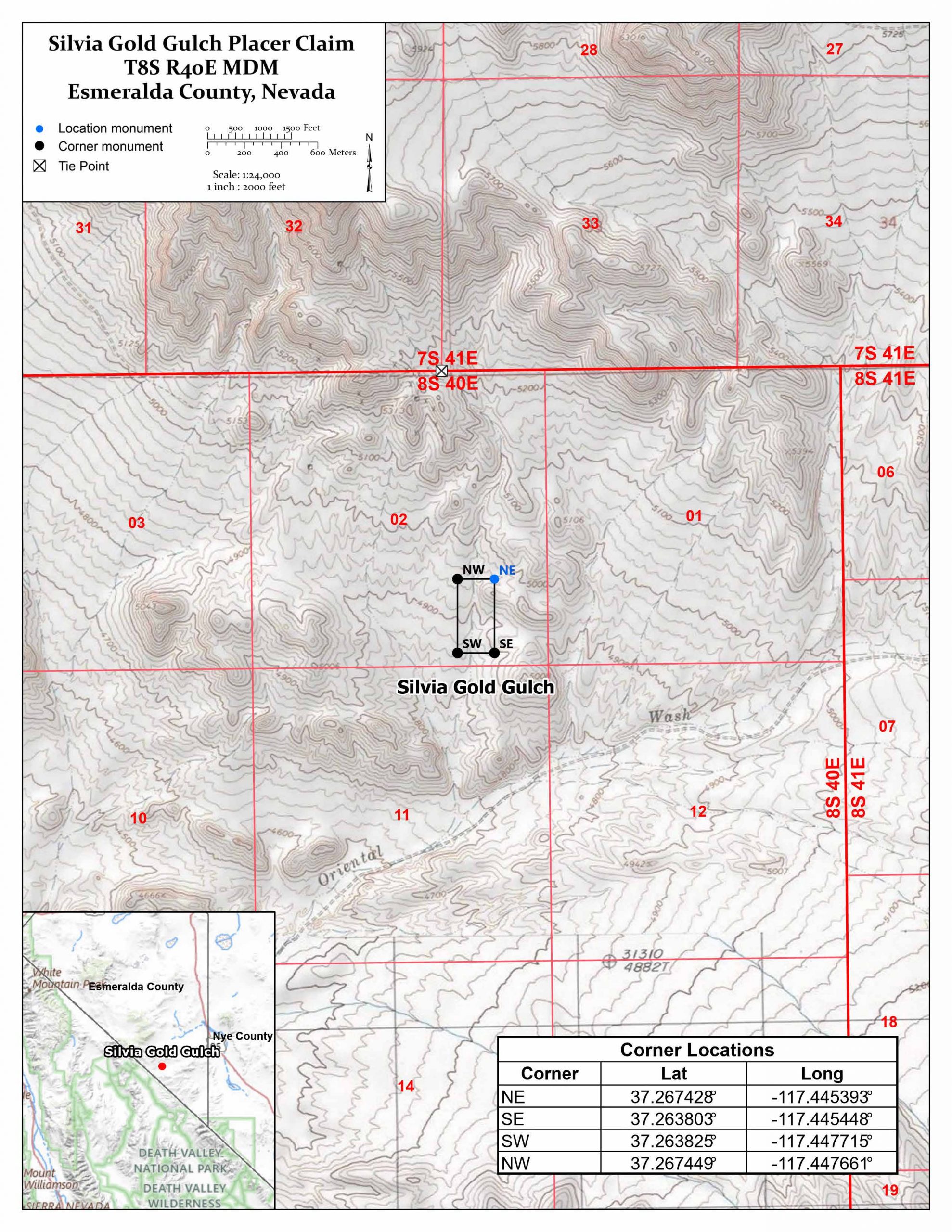
SILVIA GOLD GULCH MINING CLAIM
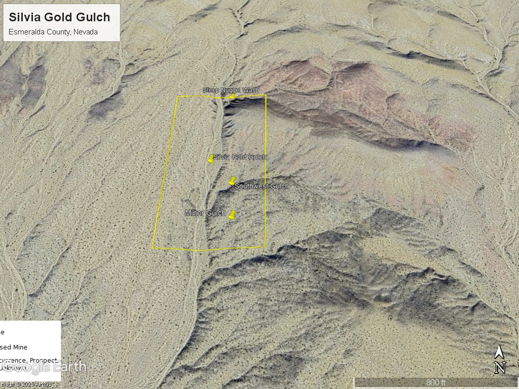
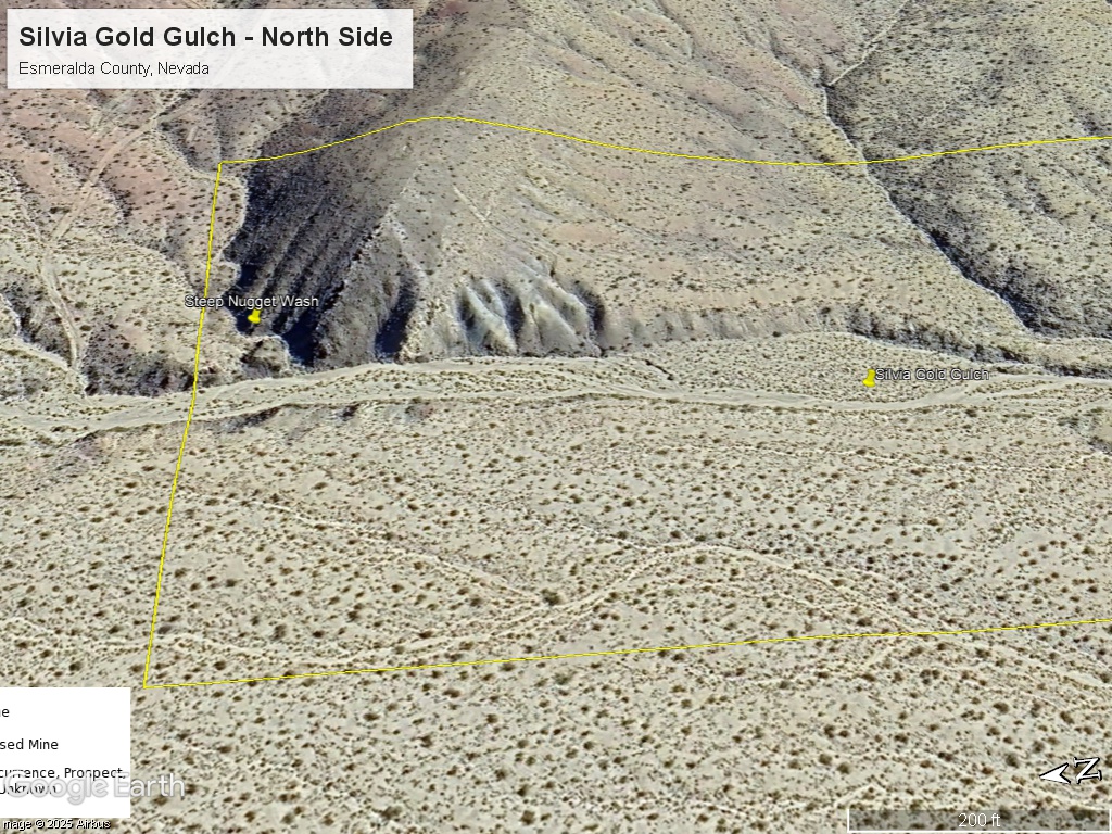
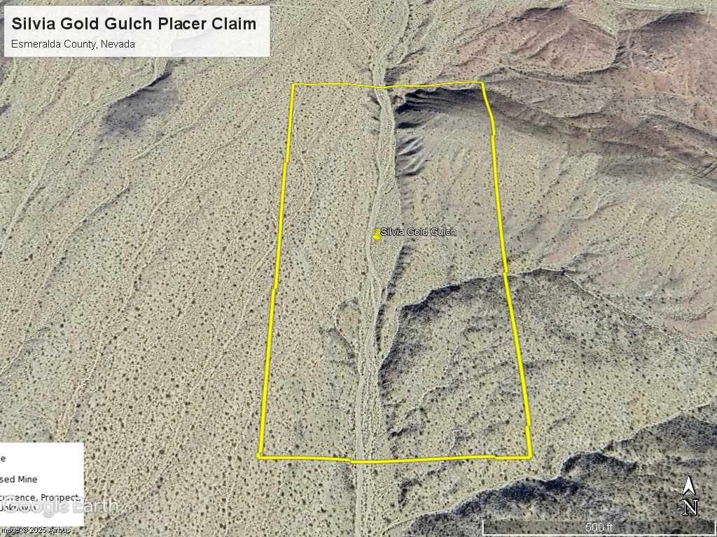
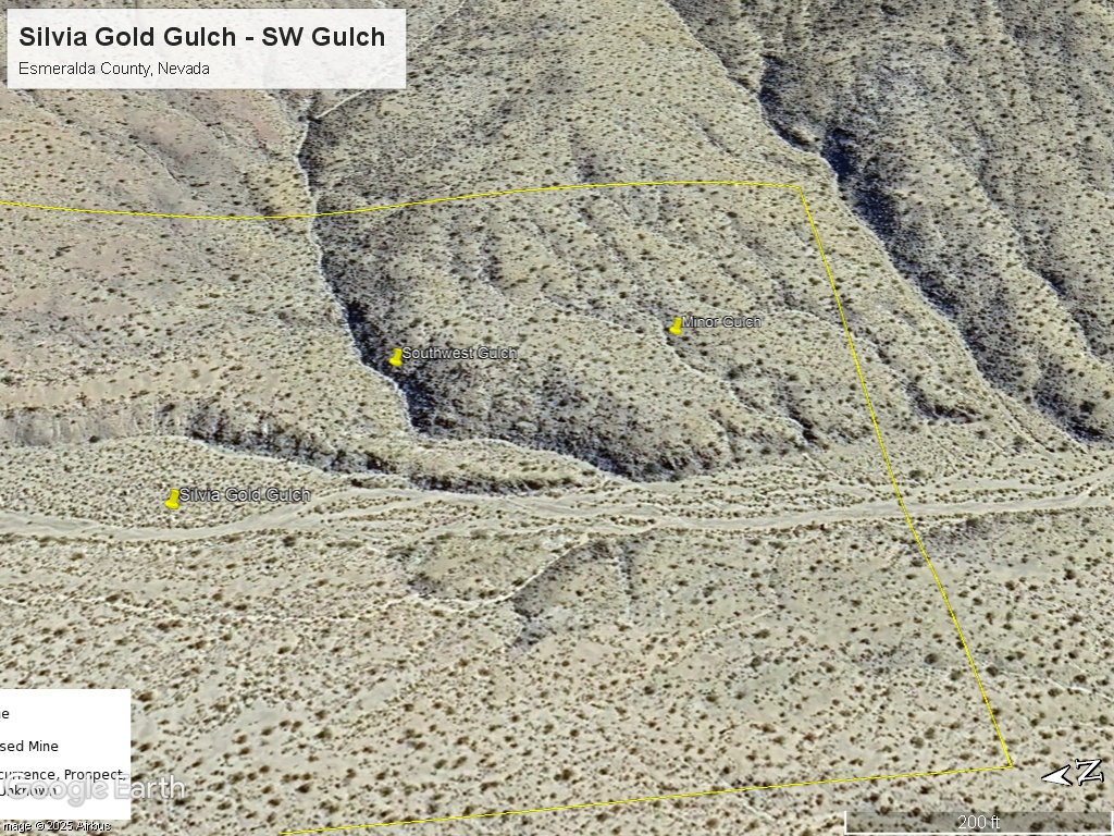
The Silvia Gold Gulch claim consists of one (1) unpatented placer mining claim, covering 20 acres, on federal land managed by the U.S. Bureau of Land Management. The claim covers a wash that drains the historical Silvia historical mines to the north in Esmeralda County, Nevada south of Lida.
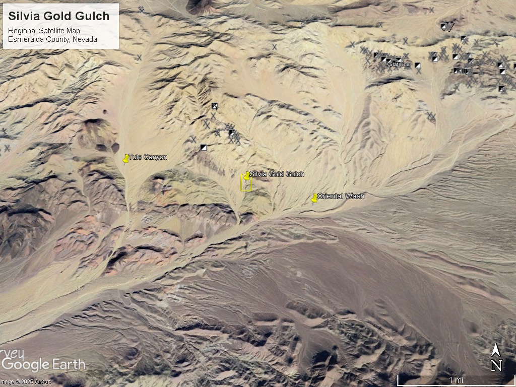
The Silvia Gold Gulch claim is in the southern part of the Gold Point District, known for high grade silver (hornsilver) and gold. The claim is situated between Tule Canyon and Oriental Wash – both famous placer gold districts.
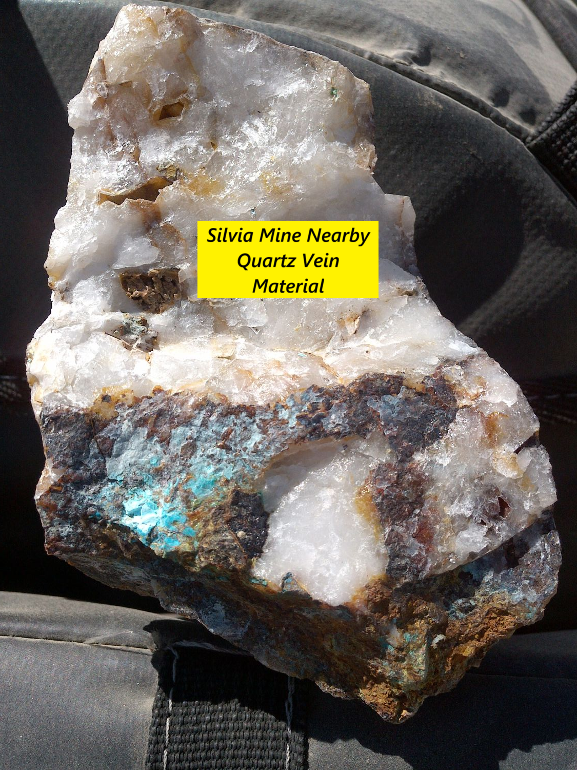
I took 2 assays on a vein at the Silvia Mine to the north and got 4-5 ounces per ton silver, 0.72 g/t gold and 2100 ppm copper. Historical veins in this area often had multi-ounce gold.
GPS Location: Latitude: 37.265602°, Longitude: -117.446716° (Center of Wash)
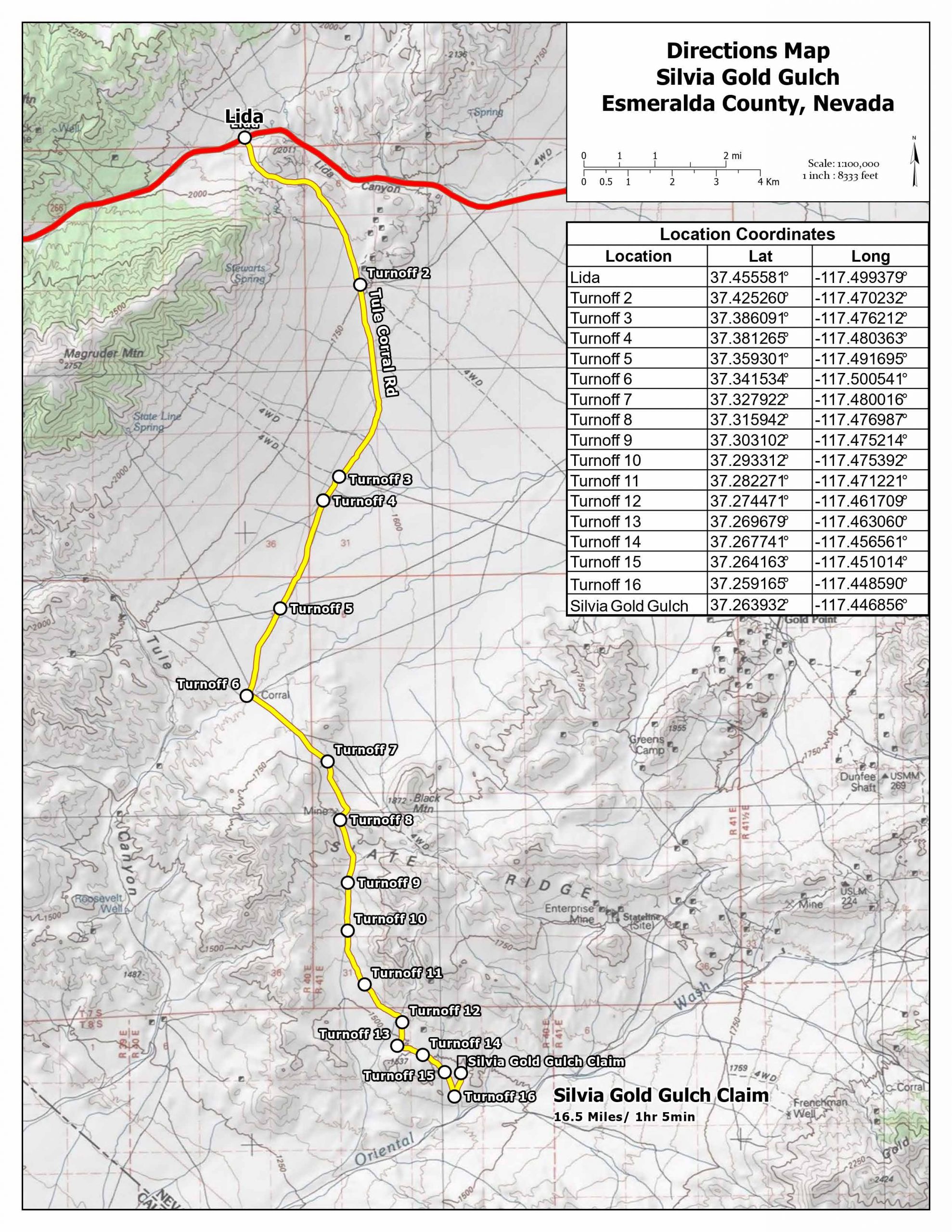
Access: From Las Vegas, Nevada drive north on Highway 95 for 163 miles. Take a left (west) on NV-266 and drive 19 miles to Lida, Nevada. Take another left at Tule Corral Rd. and drive south for 10.8 miles to Tule Canyon. There are roads paralleling Tule Canyon that you can take to the bottom of the wash. Take a sharp left at the intersection of Tule Canyon and Oriental Wash and proceed 1.66 miles NE, the turn left on the Silvia Gulch wash and proceed north .55 miles to the claim. Access is by ATV or 4WD truck or jeep.
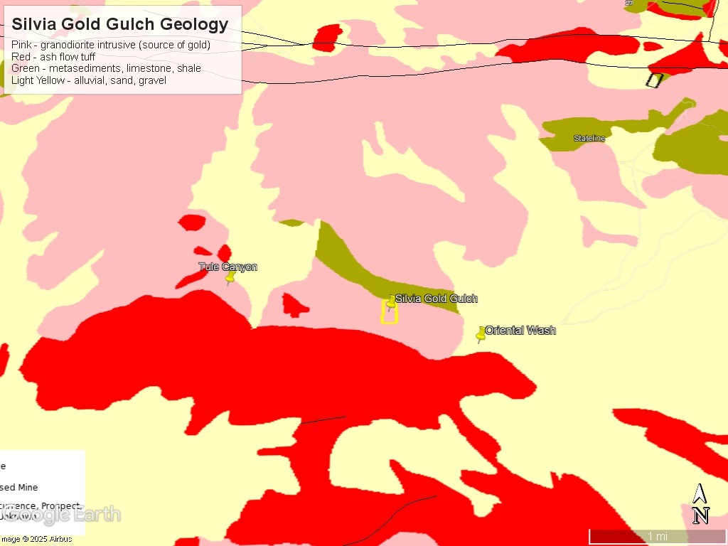
Mining and Exploration Potential: The Tule Canyon and Gold Point districts have a high density of old mine workings and numerous high-grade silver-gold veins. There is favorable geology over a wide area due to a large intrusive formation (Sylvania Pluton) that has mineralized older metasediments.
The Silvia Gold Gulch claim may have similar potential as either Oriental Wash or Tule Canyon. It is between both of them and the area is full of narrow high grade veins that erode into the washes over thousands of years.
Several hardrock mines dot the edge of Tule Canyon with reported historical grades as high as 4 gold ounces per ton.
Tule Canyon: The average depth to bedrock is 16 feet. Past operations have averaged 6 feet of pay gravels that averaged $2 per cubic yard in 1933 (0.1 gold ounces per cubic yard) (Vanderburg 1936). Much of the gold is coarse and rough and sometimes attached to quartz – indicating it has not traveled far.
Oriental Wash was limited by water historically and had even better pay grades – but less consistency as Tule Canyon.
Silvia Gulch is directly downstream from several historical gold mines and has some good placer geology.
We panned gold from the washes all around here.
This claim should be mostly viewed as a dry washing claim – but nugget detecting and limited wet placer operations should also be possible.
The largest nugget found in this area (Tule Canyon) was 52 ounces! So bigger gold is possible here.
Histories of the two adjoining mining districts: Tule Canyon and Oriental Wash are below.
The Tule Canyon District lies in southern Esmeralda County, Nevada centered around Tule Canyon. Tule Canyon starts in the foothills south of Magruder Mountain and runs east for 5 miles then turns south and runs another 6 miles where it joins Oriental Wash in the northern edge of Death Valley.
W.O. Vanderburg, the author of ‘Placer Mining in Neavda’ estimates that gold was discovered in Tule Canyon in 1876. However, many other sources have mentioned that placer mining was already been conducted in Tule Canyon prior to the 1860’s when the Nevada Territory was first being settled by Americans. Indeed, Mexican miners mentioned that Native American miners were active prior to their arrival.
In 1876, Chinese workers were imported to work the northern part of the canyon (about a mile from the TCM 1 placer claim). Due to the scarcity of water most of the mining was done by hand with small pans. That this method was worthwhile and paid suggests that the gravels were very rich.
The period between 1880 and 1895 was the busiest period and Tule Canyon got a US Post Office at Senner near the part of Tule Canyon where it doglegs south.
It is estimated that $12M in gold was mined during this early period when gold was $20 per ounce. There are records of large nuggets found during this time period. The head of Tule Canyon is named ‘Nugget Gulch’.
The Long Sam Mine was active during this period and employed three miners working gold ore worth $75 per ton (3.75 gold ounces per ton) using two arrastras.
During the heyday of the Goldfield and Tonopah mines (1900-1920) several Tule Canyon mines were listed on the local stock exchanges and were co-owned by some of the famous mining operators of the day.
William Ingalls, the well-known and popular Sheriff of Esmeralda County for over 30 years, owned one of the best properties in Tule Canyon, the Ingalls Mine. This mine was worked by lessors for over 20 years and was estimated by one source to have produced over $4M in gold (at $20 per ounce)!
Beginning in 1933, the Los Angeles Rock and Gravel Corporation worked 8 claims at the upper end of Tule Canyon. They used a dragline and shovel, standard grizzly and trommel, and powered the plant with a Ford Model A engine. They piped water from a spring in nearby Weatherspoon Canyon. I think this might be part of the pipes shown in the above pictures. They employed 12 workers.
Active mining in the District ended with Order L-208 closing the gold mines at the beginning of World War II. There have been periodic small operations since then.
A publicly traded junior mining company, Silver Range, owns several claims in the District (centered on the hardrock source of gold).
Oriental Wash History: The district was originally discovered in 1866 by Thomas Shaw. The Oriental Mine, discovered in 1871 also by Shaw, was the first big mine in the district. Ore and concentrates were shipped to Belmont or Austin, NV for processing during this period which limited production to the highest grade material. A U.S. government report in 1875 stated that ore from the Oriental Mine averaged $182.66 per ton in gold and silver while samples from 50 different claims averages $150 per ton. This amounted to approximately 5-6 ounces of gold per ton. Gold was $20 per ounce and silver was $1.30 per ounce during this time. In the nearby Hornsilver / Gold Point district silver veins at the surface often became gold veins at depth. High grade gold and silver are both common in the Tokop area.
In the 1930’s there was gold placer mining in Oriental Wash. There has been limited modern exploration in this district. In the 1980’s, Oriental Wash was tested for placer gold and a resource was discovered (International California Mining Journal, March 2000). Oriental Wash is an excellent place for nugget hunting and placer exploration.
Regional Geology: The Silvia Gold Gulch claim is located in the Walker Lane mineral belt which is part of the Basin and Range physiographic province. The Basin and Range province covers most of Nevada and consists of narrow NE trending mountain ranges between flat, arid valleys and basins.
The Walker Lane mineral belt is an area with a high density of parallel strike-slip faults extending from Reno to Las Vegas roughly along the California- Nevada border. Faulting and volcanic activity make the Walker Lane favorable for hosting gold and silver deposits including some of the most famous precious metal mining districts in the US including the Comstock, Goldfield, Tonopah, Bullfrog, Mineral Ridge, and Round Mountain.
Local Geology: The Silvia Gold Gulch is in a wash within a small mountain range to the north of Oriental Wash.
The rocks in the district are the Jurassic Sylvania Pluton (granites, granidiorite) and the metasedimentary, Wyman Formation. Wyman Formation host rocks are slate interbedded with limestone. Many gold-silver deposits in this district are in the metamorphic halo and contact between the Sylvania Pluton and the Wyman Formation.
The claim is just south of the metamorphic / granidiorite contact.
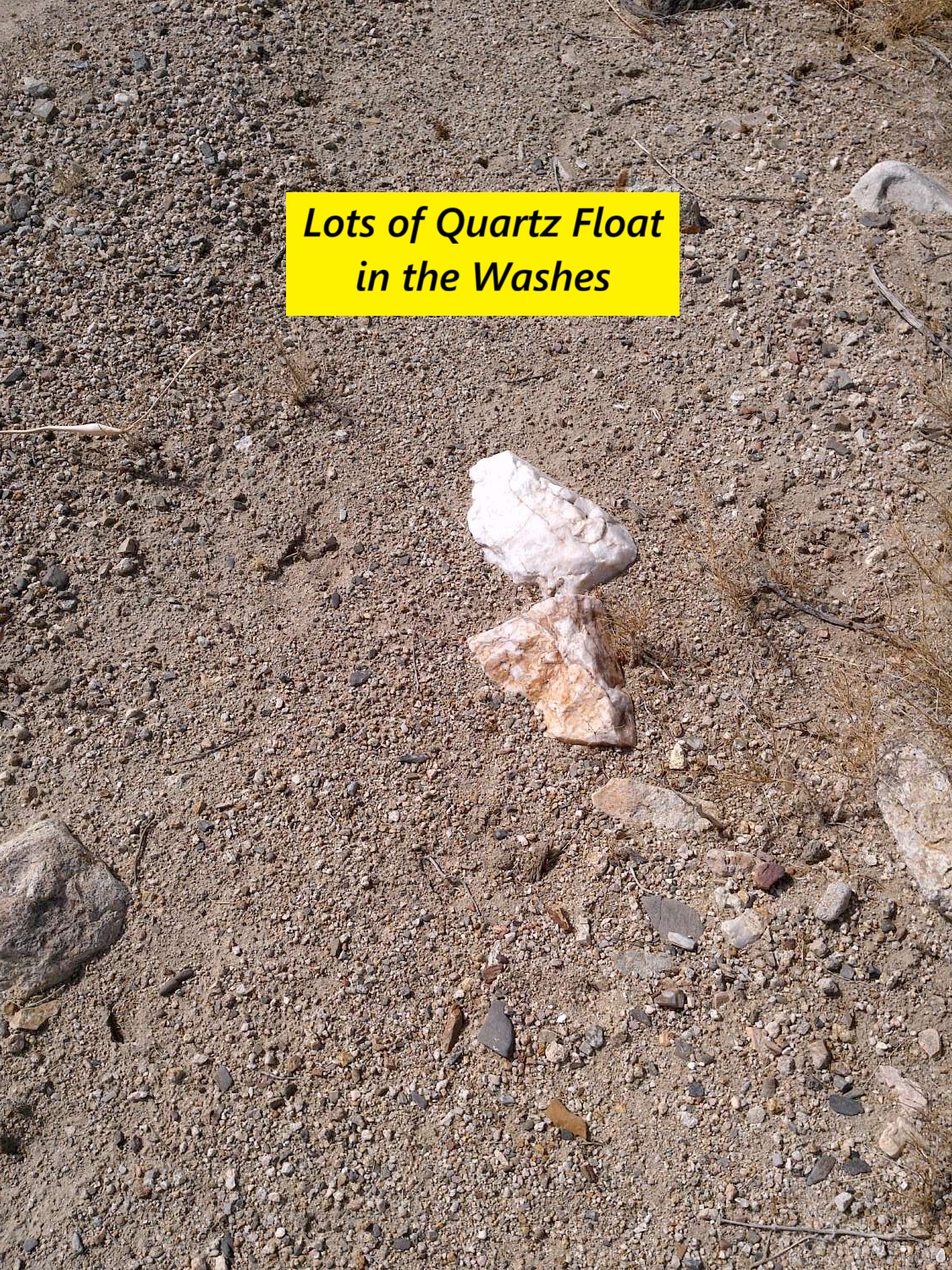
The Silvia veins were in quartz with significant copper oxides and argentite.
Silvia Gold Gulch is sands and gravel. The placer gravels should be 2-3 feet depth up to 15 feet depth. However some gold may be on surface in crevices, rocks etc.
The canyon sides may have elluvial (hillside) gold – sometimes called short haul gold. There may also be potential for additional vein deposits on the outcrop and nearby.
FAQ
Why Nevada?
Nevada is consistently ranked as one of the top mining jurisdictions in the world for being mining-friendly and continuing to produce major discoveries. If Nevada was a country it would be the 5th largest gold producer in the world (after Australia, Canada, China, and Russia). Nevada is home to the Carlin Trend, the Cortez Trend, the Walker Lane Trend, the Getchell Trend and many other prolific gold producing regions. In addition to gold Nevada also has major mines producing silver, copper, lithium, iron ore, magnesium, gems and many other minerals. Nevada is 85% owned by the federal government and most of this land is available for claim staking. This means some of the best mining ground in the world is open to small prospectors – a very unique situation. There are many mining companies active in Nevada and therefore, multiple potential buyers for any discovery you make. Canadian based junior exploration companies are particularly active in Nevada.
Why Buy a Claim?
Buying a claim is a great way to get started in mining and prospecting. Buying a claim that is professionally staked reduces your upfront work and the risk of making a mistake on your paperwork or in the field. Our claims are in areas with historical mining activity and most have numerous pits, shafts, and adits to explore. Finding these claims takes lots of research that is already done for you. The best place to find gold is where people have already found it!
Why Us?
I have been working in mineral exploration in the southwestern United States and Alaska for 22 years. I have co-founded four junior mining companies and managed numerous drilling and exploration projects. I have worked with large and small mining companies and know what types of projects they are looking for that can be advanced by small prospectors. I have also worked on small hardrock production projects. I usually try to find claims that have known high grade veins that can be produced and that also have some exploration upside. We stand by our claims and fix any problems that come up. We can also help you with your annual filings. All our claims have a BLM serial number and can be found on the U.S. BLM MLRS website database. Our maps are professionally drafted.
How is ownership of the claim transferred?
Ownership of mining claims is transferred with a Quitclaim Deed which we prepare. We pay all claim transfer fees and file the claim transfer paperwork with the BLM and Esmeralda County. The BLM takes about 2-3 weeks to process the claim transfer request and register the claim in your name. The Esmeralda County Recorder usually returns the Quitclaim Deed same day when filed electronically. Once the transfer is complete we will send you all the original documents including the file stamped Quitclaim Deed, the original location notices and claim maps.
How Much are the Annual Claim Fees?
The BLM charges a $200 per claim annual maintenance fee which is due on September 1st each year. The BLM fees can be paid online through their claim management portal. Esmeralda County requires that a Notice of Intent to Hold form is filed the first year by Nov 1st along with payment of the recording fee of $12 plus $12 per claim.
If you own less than 10 mining claims you can qualify for a waiver of the annual maintenance fee by filing a Small Miner’s Waiver. However, the Small Miner’s Waiver requires that you perform $100 in labor or improvements on the claim each year.
International Buyers
International buyers must either have dual US citizenship and US address or have a US entity or company to own the claim.